E4 - a walk through the mountains of Crete: Introduction

This is my log of the E4 long distance walk along the spine of Crete from East to West - it is intended to be a useful resource for others who are contemplating a similar walk; it is not intended in any way to be a complete route guide. For my preparation, I read Christopher Somerville's "The Golden Step", Christopher Thorne's "Between the Seas" and Stelios Jackson's wonderful account on the Interkriti website. They are all useful in their own way and between them they give a full history of the island.


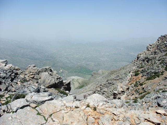
Part One of this walk along the E4 in Crete is from Kato Zakros on the east coast to Fourfouras in the Amari Valley. This is about 285 kilometers and took me a total of ten walking days, starting at the beginning of June 2011. I managed to reach the summit of the main ranges along the way – Thripti, Dikti and Psiloritis. Although this is above and beyond the call of the official E4, I felt it was in the spirit of the E4 and, in Part Two, I have also gone off-piste in the spirit of spine-walking. 


Part Two of the walk is from the Amari Valley to the Chrisoskalitisa Monastery on the west coast. This is about another 170 km and took a further 8 days (including a rest day at Askyfou). This part includes the two day crossing of the White Mountains, with a trip to the summit of Pachnes to complete the set. This was done at the end of August 2011.


This is the Elevation Profile for the complete 455 kilometre walk along the spine of Crete :


I have to say that, for navigation, I relied heavily on the Anavasi map on my Garmin GPS (http://www.toponavigator.com/el/cartography/topo-region.html?page=shop.product_details&flypage=flypage-topo.tpl&product_id=88&category_id=9). Reading other accounts of this sort of E4 walking adventure, I realised that a lot of time can be lost going round in circles and a lot of beautiful paths can be missed because often there is simply no way of knowing where the E4 is supposed to be on the ground. In conjunction with the GPS map which was very accurate, I used the three 1:100,000 Anavasi maps which cover the length of Crete - thereby minimising the weight and bulk of lots of more detailed paper maps.


NB - the maps I have used at the start of each chapter are NOT Anavasi maps - they are something I found free on the internet and they are totally inaccurate. Do not rely on these maps !!


I also could not have done without Loraine Wilson's amazing guide book : The High Mountains of Crete: A Walking and Trekking Guide: The White Mountains, Psiloritis and Lassithi Ranges (Cicerone Mountain Guide). Both Loraine and Anavasi (Triantafyllos Adamakopoulos) were extremely supportive before and during the walk and I am grateful to them both.

As far as "kit" went, I strapped 2 Powertraveller solar panels to my Osprey (70 litre) rucksack to recharge my GPS batteries daily. This system also recharged the Powermonkey for my iPod and my mobile phone – all essential bits of kit – and it all worked extremely well.

I also carried a tent, camping equipment, dried food and isotonic powdered drink sachets, so with all that and the battery charger I didn’t need to leave the E4 trail at all to find overnight accommodation or fresh batteries. I just needed to pick up fresh water from time to time.

My kit for the walk on the E4 in Crete
- about 18 kg (including minimum 2 litres of water)


Some thoughts on blisters:


Before embarking on the walk, I walked and trained extensively (with full pack), mainly in the Yorkshire Dales where we live. Our local hills are the Howgills and the highest point is 676 metres; the ground underfoot is springy turf.


My boots were conventional Brasher boots (at least half a size larger than I normally wear) with a good EVA cushion above the rubber tread. I wore wool socks and had an orthotic insole with some anti-pronation angle and I used this combination for a good six months, including a month in Crete both on roads and on the limestone rubble that passes for paths there.


What happened on Part One of the walk was that my feet swelled by at least a size and my little toes were squeezed under their neighbour to excruciating effect. At the same time, especially on descents, the balls of my feet got deep blisters, which I tried to manage with Compeed plasters.


For Part Two, I made the following changes :


1.    I changed to my "Keen" walking boots which have a really wide toe box and are a further full size bigger. They are not as rugged as the Brashers, and have less ankle protection, but they feel like slippers !
2.    By knotting off the laces above the lowest lace point, I could stop the toes being squeezed even when the laces were pulled tight higher up.
3.    I changed back to "Sole" Softec Ultra custom footbed insoles (which are a bit narrower at the toe than the Keen toebox shape) and did a bit of "art and craft"with the original Keen insoles to make sure there were no ridges inside the boots in the toe box area. These Sole insoles are stiff enough to compensate underfoot for a slightly less rugged boot and at the same time they have a wonderful depth of cushioning (Sole Unisex Softec Ultra Insole).
4.    I also changed to "Sole" dual layer blister protection socks ("crew" length), again at least 1 size bigger than I usually take. These take up much less volume than conventional wool socks and they deservedly get good reviews for their blister protection qualities.
5.    I tucked a small pad of raw, washed, sheep's wool (inside the socks) just in front of the ball of my left foot where two toes have lost some of their natural spring and leave the ball itself vulnerable to deep blisters. The wool moulded itself to the shape that the toes should have had without ever becoming hard or uncomfortable and I expect the natural lanolin helped a bit as well.


The result was truly miraculous and I reached the end of Part Two with nothing worse than a sore little toe. What a pleasure to be able to walk pain-free through that wonderful landscape !    


The E4 Trail: Kato Zakros to Zakros

Wednesday 1st June               (Chania to Kato Zakros by bus)

The E4 Trail: Kato Zakros to Zakros


6.7 km                        1.5 hrs.              mov av  4.9 km/hr            Height overnight 225 m


It all started with the 0630 bus from Chania to Heraklion ; while at the Heraklion bus station, I was accosted by Grant from Wellington, New Zealand who was here for Battle of Crete week and military history. He liked my  Chaniotiko katsouna (shepherd’s crook) and wanted to get one for himself. I said that knife shops (of which there are many in Chania – I don’t know about Heraklion) usually have them.

Then the 1045 bus from Heraklion to Siteia – it paddled all thro Hersonissos and Malia and felt as if it would be very late. It left Ag. Nik.  about 1230 but still managed to get into Siteia by 1410. The timetable published on the internet had suggested that there is a bus from Siteia to Kato Zakros at 2.00 pm, and I had rung to check that this bus would wait if there were people on the bus from Heraklion wanting to travel on. But .... there is no bus to Kato Zakros on a Wednesday (or a Thursday). However, the same bus was going to go on to Vai via Palaiokastro, so I stayed on till Palaiokastro and hitched with a couple of very chatty Polish blokes who took me out of their way to Zakros and I was there by 3.00 pm. Stage One had been accomplished.

Kato Zakros


I checked into the Zakros Hotel (18 euros) and left the rucksack in my room. Marcos (who is the hotel owner and who also farms 600 olive trees) very kindly gave me a lift down to Kato Zakros. I picked up two pebbles from the beach there and got the sole of my right boot wet enough to say I had paddled in the sea. “Dead's Gorge” (sic) is an easy 1.5 hour walk back up to Zakros – even easier without a pack

The Gorge of the Dead


There are plenty of day walkers in the gorge but, amazingly, these were the last walkers I would see until I got to Dikti.  That evening, I investigated the E4 path out of Zakros for the following morning – it starts a short way south of Hotel Zakros on the main road and is signed up to the right along with signs for old water mills and the like. You have to poke about a bit in the upper levels of Zakros to be certain of being on the right path but upwards and westwards is  the key.


The E4 Trail: Zakros to Vori

2nd June

The E4 Trail: Zakros to camp near Vori


24.1 km            8 hrs 40 mins.       move av  4.4 km/hr            Height overnight 260 m

Looking back over Zakros
This is a fabulous start to the main walk, especially the first part from Zakros to Ziros across the high plains at about 700 to 800 m. The climb up out of Zakros on the old mule track (kalderimi) is gentle even if a bit broken and a bit overgrown in places. You pass the beautiful and remote church of Aghios Georgios set in the middle of high pastures – particularly green this year because of the wet spring. There is a lovely monument here to those locals who died in the last war.

Aghios Georghios church and the monument to the fallen

Somewhere in the middle of Psilo Kefali there is a stock fence with a gate for E4 walkers. If you have deviated off the path at all you will need to get back on it here in order to get through this obstacle. E4 waymark poles are few and far between, but there are a few cairns at critical points. Beware – one goat path looks much like another and so does the E4 !

You then drop down into Ziros. Ziros seemed rather surprised to see a walker but nevertheless managed to provide a soft drink in the shade. I soon realised that, with no orange groves at this end of the island, getting a freshly squeezed orange juice is not as straightforward as it is in the west of the island.

The road walk on to Chandras is a bit tedious, but is rewarded with an excellent opportunity for refreshment at The Lemon Tree. An English couple Anita and Mark have done up this place right on the main road into Chandras. Anita had spotted the lone walker on her way home from picking the kids up in Ziros and had sent Mark (excellent chef) off to get food in anticipation. This is not an omelette and Mythos moment, it is a perfectly cooked and presented fish with Kaiser moment (15 euros). They do rooms as well, so potentially this is also somewhere to stop for the night especially if you have started the day at Kato Zakros (28430 31066 / 6978817210). (Sadly, Mark and Anita have returned to the UK for the foreseeable future as of Autumn 2012, so the Lemon Tree is unlikely to be operating except in the summer holiday months.)

There is an unofficial shortcut dirt road (shown on the map but not on the GPS) running northwest from Armeni which cuts out Etia and a corner of the main road, but once back on the main road it is a slog down to Vori (bypassing Papaghianades). I had earmarked somewhere round here for my first night of camping so I walked into Vori to top up with water for the night. Vori is several steps back in time – it reminded me of the Anatolian villages described by Geoffrey Eumenides in his book “Middlesex”. Anyway there is a village tap where everyone seems to get their water and I was welcome to use it.     

Campsite near Vori
There are lots of olive groves either side of the track running westwards along the E4 (unmarked here) down into the valley from Vori, so I found the scruffiest - and least likely to be tended in the cool of the evening - and relaxed for the night, disturbed only by the occasional barking dog and planes going into the new airport at Siteia.


The E4 Trail: Vori to Orino

3rd June

The E4 Trail: Camp nr Vori to Orino


24.7 km            9 hours            Mov av   4.3 km/hr            Height overnight  605 m. (max 775 m.)

I set off next morning at 0700 after a 0545 start. Soon there are interesting variations on the E4 route. The short, direct, one marked with E4 signs ends in an olive grove with no way out ! You keep climbing on the basis that you will meet up with the Anavasi version of the route and then all of a sudden you find the dreaded stock fencing. I was lucky to find a way through (over) it, scramble up and over a ridge and see the easier, but longer, dirt road alternative on the other side of a full-flowing river. However, my choice of route seemed to be what the EOS expects you to do, as suddenly, and quite unexpectedly, there was another rare E4 sign on my side of the road on the way down to the river. I forded the river and finally joined the dirt road running north towards Kato Kria. No wonder everyone’s navigation fails on this section.

  
Looking back to the South coast


The dirt road leads you on an easy uphill gradient leading northwest towards Kato Kria. This is a beautiful green valley with the river below you on the left. At a certain point, with no help from signs of any sort, you have to dive down to the left to cross the river and follow a cement road up to Dafni – otherwise you end up in Kato Kria and well off the E4. If you poke about in Dafni you will find the central square with plane trees and running water – and the usual tribe of elders encouraging you to sit and hear their life story.


The E4 Trail with Thripti in the distance


The high level walk from Dafni to Chrisopighi sets off on a dirt road somewhere between the square and the tarmac road and is also delightful (but completely unmarked until the right turn down to the tarmac road) and is a pleasant alternative to the main road below, which eventually you have to join anyway for the last couple of kilometers into Chrisopighi.


Walking into Chrisopighi


Chrisopighi has a wonderful kafeneion, which Despina runs with a happy smile. Fortuitously a megaphone fruit and veg merchant was selling oranges in the square. Despina seemed happy for me to buy four oranges for her to juice for me which was an effective way of getting some fruit into me ! She made me a huge omelette and a huge salad served with Lemonita, beer and water and the bill came to 11 euros which was probably the best value on the whole trip.


The cross-country route from Chrisopighi to Orino, as marked on the map, is a mix of fantasy and fact – mainly fantasy. It took me 3 hours. The route has to follow the dirt road uphill rather than a mythical path along the dry riverbed that is blocked by some very robust stock fencing and a lot of undergrowth. Eventually these two routes meet anyway - somewhere near a house with uncontrolled dogs and then the path dives off, unmarked, southwestwards along a splintered path marked occasionally with red dots. Both the dots and the path peter out quite quickly and I was navigating with blind faith in the GPS up and over a rugged crag and across overgrown “meadows” until lo and behold an E4 pole came into view on the horizon.

Orino with Thripti in the background
From there it was a simple descent into Orino on the tarmac road and a bed for the night courtesy of friends from Athens with roots in this lovely high-level village running with water. There are a couple of tavernas in Orino, but no “rooms” as such - there are no obvious camping spots either so a night spent round here could be uncomfortable.


The E4 Trail: Orino to Metochi Asari

4th June

The E4 Trail: Orino to Metochi Asari


32.2 km            11.5 hours            Mov av  4.2 km/hr            Height overnight 330 m. (max 1,476 m)

There now followed two 30-plus kilometer days aggravated by the fact that I wanted to summit each range that I passed through - even though there is no strict E4 requirement to do this. So, I set off from Orino by 7.00 am on the clearly marked dirt road which is the pass through the mountains towards the village of Thripti. It did seem to take for ever to reach the turn off for the vehicle road to the summit which is clearly marked (Afendis Stavromenos), but eventually I reached it and plodded up on the basis that if I missed this summit then I might always regret it.  There was a curious incident with some sheep dogs that had to be called off but I finally arrived at the summit (unscathed). It was a clear morning and the 360° views were definitely worth it.

The fabulous view looking south east from the summit
The stone signpost for
the dirt road up to Thripti
(Afendis Stavromenos)
 The footpath down the north west slope, as marked on the map, seemed an impossibility – the drop is sheer and surely not even goats use this descent ? After yesterday’s cross-country experience, I thought it would be prudent to ring Triantafyllos (Anavasi maps) for confirmation – it was his map after all. From his office in Athens he was able to confirm that he could see the path on his satellite pictures and that the starting point was exactly as marked on the GPS. So down I went – a bit loose and slippery but a path nevertheless and it got me safely down to the village of Thripti where I was able to take refreshments in a slightly surly kafeneion.
Looking back at the west face of Thripti 
and the (not discernible) path down

The Ha Gorge from above
From there, a labyrinth of dirt roads runs down the higher reaches of the Ha Gorge (some maps call it Monastiraki Gorge) through shady pine forests giving tantalising glimpses of the iconic slash in the rock wall. The signing here is intermittent but the main principle is to keep as close to the gorge as the roads permit. The GPS track is 100 % accurate here - and all the way down to Monastiraki. Eventually you are led off south westwards on a red spot marked path to gently descend the west facing rock wall before turning back north eastwards on a dirt road to Monastiraki where there is a very welcome, and welcoming, taverna.

The beautiful Gulf of Mirabello

It is a short walk across the “trench” south of Pachia Ammos to Vasiliki where I took on water at the public taps in preparation for an overnight camp somewhere on the road to Meseleri. Getting out of Vasiliki on the right road was the hardest part because neither GPS nor E4 signs were going to help. I could see from the paper map that I needed to be behind the small town on the uphill side to the west. When I asked advice about the right route for Meseleri, I was constantly advised to take the main roads as if I was going by car – which most people here probably would. The lesson is to ask for places much closer to the point of departure because in the course of conversation one man told me that the dirt road (which was looking promising) went as far as Metochi Asari - which was exactly on my route – bingo ! Off I set in the late afternoon sun and after 1 km came across an E4 sign – not a lot of help for finding the way out of Vasiliki, but reassuring nevertheless. 

Looking back (east) towards the Ha Gorge


My diversion up Thripti earlier in the day meant I wasn’t going to reach my target of Meseleri before the legs gave up so I stopped just short of Asari on a flat pasture area at about 6.30 pm – my peaceful camp site for the night. (It is worth mentioning that, by and large, the locals do not seem concerned about campers in these remoter areas.)                        

My campsite near Asari

The E4 Trail: Metochi Asari to Selakano

5th June

The E4 Trail: Metochi Asari to Selakano


38.5 km            11.5 hours            Mov av   4.7            Height  overnight 887 m. (max 1,100 m)

I was 9 km short of where I had wanted to be so I had some ground to catch up if I was going to manage Selakano that night and Dikti the following day, so I was back on the dirt road by 6.30 am. About 8.00 am I passed the monastery Panayia Vriomenou which also provided some level green areas suitable for a tent and where I had hoped to get to the night before. I was in Meseleri by 9.00 am that Sunday morning where the kafeneion was full to bursting with a 6-month memorial gathering and I seemed to be given a share of their breakfast meal without even asking.

The monastery Panayia Vriomenou
A familiar sight on the E4

It was then an asphalt road tramp via Prina to the turn off for Aghios Nikolaos church where I stopped for a breather before the slow ascent along dirt roads to 1,100 metres. This is a long but easy tramp with fabulous views down over Ierapetra and it is one of the routes into the Katharo Plain above the Lasithi plateau. The GPS certainly gave me confidence whenever I came to junctions and occasionally the fairies who put up the E4 signs reassured me as well. If ever there was a “walk of the gods” it is here, as it contours round under Chalasmeni Korfi at over 1,000 metres and becomes steadily greener and more wooded.


Dikti in the distance and the north coast
It has to be said that this is a very long section of dirt road and there is no easy source of water up here – there are shepherds’ houses along the way but they didn’t seem to be obviously occupied and their dogs certainly weren’t going to let me in to fill up my bottles. However there was water eventually in the river running down the gully in the Selakano Forest and it tasted clean enough. 

As I hadn’t been able to contact Kyria Stella on her landline in Selakano, I wasn’t 100% sure that there was going to be a bunk there for the night.

However I had read up Loraine Wilson’s (LW) instructions for finding the start of the path off the dirt road and down through the Selakano Forest and was ready for a good beer or two at the bottom. It all looked so easy on the map. But the path sadly was not marked on the GPS and things are never quite that easy – there had been fires in the area recently and too few people had been walking the E4 path through the woods to keep it obvious on the ground. Additionally, the wet spring had led to an explosion of greenery everywhere, further obscuring clues.

The path becomes greener
So I kept to the left of the watercourse as instructed by LW and followed a line on the GPS which would get me to the dirt road which leads into Selakano. It all took much longer than I had hoped and at the end of a long day the legs were certainly tired. A volley of stones at an aggressive stray dog (I missed) helped me feel better and by 6.00 pm I was being reassured by Stella and her son Nikos that there was a bed for the night in the bunk room (10 euros), for which Stella has the key. There was also a super meal of goat and greens and soon the pain of nearly 40 km started to subside. (Stella’s mobile is 69457 70055.)


The bunk room in Selakano -
it can sleep six people comfortably

    
Looking back at the descent through the Selakano Forest
(top centre of picture)


The E4 Trail: Selakano to Lasithi Plateau

6th June

The E4 Trail: Selakano via Dikti summit to Aghios Georghios (Lasithi Plateau)


22.0 km            9 hours            Mov av   3.4 km/hr            Height overnight  824 m. (max 2,148 m)

It was a familiar performance trying to find the right path out of Selakano. T's map v T's GPS (didn't show the start) v LW's words. Together they made no real sense, because the map was saying that the footpath ran due west out of Selakano while LW’s suggested route was taking me north. In the end good old red paint splashes got me going westwards along a concrete path (starting beside a concrete structure) not far north of the junction between the bunkhouse square and Stella’s taverna. You have to follow your nose here as the paths stop and start a bit, but the GPS did clutch in quite quickly and, as ever, was reliable.


On the way, westwards, out of Selakano in the early morning light.


Asfendami spring

It was then a long, slow but very beautiful flog up and up along different paths and dirt roads through the pine woods of Selakano forest, full of the hum of bees and bee hives, and then at last I was on the proper footpath up to the Asfendami mitato. First appeared the dog, then two shepherds who cleverly recognised my stick as Xaniotiko and who persuaded me the dog was OK – and, finally, the spring. At over 5,000 feet this gushes into a trough all year round (once you have extracted the shepherds' lastiko / hosepipe). The water is wonderfully cold, clean and clear and sufficiently reliable not to have to carry the whole day’s water requirement up from Selakano. But there is no easy water from here to Lasithi (without significant detouring) so you do need to fill up with enough here to see you through the rest of the day.

View west towards the Avasami pass


Route finding thereafter is very straightforward courtesy of the E4 sign providers and the GPS. I got to the Avasami pass in about four hours and made the decision to give the Dikti summit a go. My wonderful Christmas present Osprey rucksack splits into two and I took the top, tumbag, bit with me on the easy path to the summit (50 mins up and 35 back). I way-marked the hidden main bag and had no problem finding it again on the way back down. 


It was a bit of a surprise to see someone ahead of me on the way up to the summit as I hadn't seen a single walker since leaving Kato Zakros. It turned out to be Achim from Dortmund who had been granted a day's leave from his family in Malia to get some exercise. 

The view back southeast from the top of Dikti


Sadly, the fair weather had produced quite a haze so the view wasn't quite as spectacular as it had been when Susa and I were last there. Nevertheless it is a stunning place to be and it was well worth the effort. Two peaks down and two to go. Regrettably the rapid descent down well-marked paths to Lasithi plateau and Aghios Georghios was blister-popping, so now I had that problem to contend with on a daily basis, just like so many cross-Crete walkers before me. 


The northwest face of Dikti


The (hazy) Lasithi plateau is the reward for hard work !


Today's walk was 9 hours including Dikti. LW has it as 8.5 without Dikti so not too bad I felt, but I had paid for it with the blisters. Hotel Dias has stopped being a hotel so I stayed at Hotel Maria for 25 euros a night which I felt was quite steep. However Dias had pastitsio on the menu so it got my custom - good to share the tourist dollar about. 

Anxious locals told me that it had been so wet through the spring that they were now a month late getting their potatoes out of the ground – strange weather this year, but useful local knowledge !

Dikti over the rooftops of Aghios Georghios


The E4 Trail: Lasithi Plateau to Kasteli

7th June

The E4 Trail: Aghios Georgios (Lasithi Plateau) to Kasteli


23.5 km            7 hours               Mov av   4.7 km/hr                   Height overnight 335 m. (max 824 m)

This was another delightful start to a day’s walking. Rather than tramping round the perimeter which is more or less where the E4 is supposed to go, it is quite possible to take a diagonal line from the south east corner to the north west corner by taking a right, then a left, then a right etc so you end up close to Kato Metochi. This way, you get to see close up the extent of the agricultural activity going on around the plateau in the morning sunshine. You also get to see the newly formed baby frogs – fresh from tadpole status – hopping happily in the sunshine in front of my big boots.


Lasithi Plateau in the early morning light.


The left turn in the top left hand corner heading west towards Kastamonitsa and past the famous Chonos (“drain hole” for the Lasithi) is pretty obvious. What is much less obvious is where the E4 path goes once the tarmac road has done a 90 degree turn to the left after about a kilometer. A small dirt road heads off in the right general direction but confusingly starts to swing right towards a small work station. The GPS immediately told me I was deviating, so back I went and followed the GPS blindly through some very long grass and straight into a stock fence. I was able to get over it (without doing any damage) and once through, it was an “open sesame” moment as I immediately stumbled onto the kalderimi which leads up to the rim of the plateau.


At the rim there is a 2008 monument which celebrates two things: the “Minoan path” between Lyttos and Dikteo Andro cave (also described at the bottom as a Roman Aqueduct and by most as a Venetian mule track) and the Grave of Tsoulis – an evil Turk who was murdered by locals in revenge for his atrocities against Christians. All that needs to be said is that this mule track is beautifully engineered as it sweeps backwards and forwards dropping 1500 feet down the north west face away from Lasithi. This is perhaps the most impressive man made construction at this end of the island – and the views across the north coast are stunning (luckily you can’t see the reality of Hersonisos and Malia from this height).


At the bottom, it is a bit of a dirt road tramp along to Kastamonitsa with a welcome water tap at the road junction to Tichos and Litos. A little further on, as you come into Kastamonitsa, the road splits. Stay left here to get directly to the centre. In Kastamonitsa itself (a pretty village with lots of flowers), there is a very friendly kafeneion where I was well refreshed and entertained. 

The road tramp from here to Kasteli is unremarkable apart from the fact that there is an airstrip laid out in front of you as you descend into the town. I wondered if the new Heraklion airport was already under construction, but no, it is a military airfield and as far as the locals are concerned plans for the new airport are very much on hold (to their relief).


Hotel Kalliopi, as promised by other writers, does have a pool – which turned out to be full of very excited and very noisy Greek kids relaxing after a hard morning at school. However, it was a pool and it was wet and cool and blissful, even if I did feel like a fish out of water in amongst these sadly obese youngsters. I was the only paying guest (25 euros a night).

Kasteli itself has a prosperous feel which has nothing to do with tourism and everything to do with these rich agricultural hinterlands to the south of Heraklion - and it also has a brilliant Pharmacy which is well equipped to provide the wherewithal for blister relief.